
 T
T
ree disputes once depended heavily on memory, handwritten notes, printed photographs, and conflicting accounts between neighbors. Today, information technology is changing how property owners, attorneys, surveyors, arborists, insurance professionals, and local officials collect and review information involving trees, property boundaries, storm damage, and neighborhood disagreements.
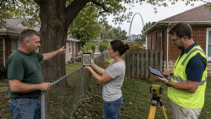
The change is especially noticeable in a city such as St. Louis, where mature trees, older neighborhoods, closely positioned homes, alleys, utility lines, and long-established property boundaries can create complicated situations. A large branch may cross a fence, roots may extend beneath a driveway, or a storm-damaged tree may fall across two properties. When the people involved disagree about what happened, digital records can provide a clearer timeline.
Modern tree disputes may now include geographic information systems, property databases, smartphone photographs, security-camera footage, drone imagery, weather records, text messages, cloud backups, and electronically filed court documents. These tools do not replace legal advice, professional surveys, or qualified tree inspections. They do, however, give the parties involved more information than previous generations of property owners could easily obtain.
For St. Louis residents dealing with a boundary tree, damaged property, hazardous limbs, or another tree-related concern, a knowledgeable Tree Law St. Louis professional can help connect the physical condition of the tree with the records, evidence, and property information surrounding the dispute.
Digital Mapping Is Making Property Information Easier to Access
One of the most important changes involves digital mapping. Geographic information systems, commonly known as GIS, combine maps with layers of location-based information. A GIS platform can display parcel outlines, addresses, streets, buildings, zoning information, aerial photography, and other records in one digital environment.
The Wikipedia overview of geographic information systems explains how GIS technology is used to store, manage, analyze, and display geographic data. Although GIS has applications ranging from transportation to environmental science, it has become particularly useful for local governments, property professionals, utility companies, engineers, and residents trying to understand land-related information.
The City of St. Louis maintains geospatial research and GIS resources that support mapping, planning, and location-based research. These resources demonstrate how deeply information technology has become integrated into modern city management. What once required a visit to a government office may now begin with a digital map viewed from a home computer.
This access can be valuable during a tree dispute. A property owner may use an online map to understand the general configuration of neighboring parcels, locate identifying parcel information, or prepare for a conversation with a surveyor or attorney. Aerial images can also help show the historical placement of a tree canopy, fence, driveway, garage, or other visible feature.
Digital parcel maps still have limitations. A line displayed on a public GIS map should not automatically be treated as the exact legal boundary between two properties. Map layers can be based on records created at different times, and the visual line may not account for the precise location of survey monuments. A licensed surveyor remains the appropriate professional for establishing a legal boundary in the field.
Online Property Records Provide a Starting Point
Information technology has also made property records more accessible. The City of St. Louis offers an official address and property search that allows users to review information associated with an address or parcel. Available records may include assessed property information, ownership details, permit activity, and ward information.
For properties outside the independent City of St. Louis, the St. Louis County property lookup system provides access to parcel and property information through the county’s open-data resources. The county also maintains a geospatial data center with mapping applications that can assist residents and professionals conducting preliminary property research.
These databases can help identify the recorded owner of a parcel, verify an address, locate a parcel number, or gather background information before requesting deeds, surveys, permits, or additional documentation. When a rental property, vacant lot, commercial building, trust, or business entity is involved, finding the correct owner can be an important early step.
Online records may also reveal information that affects how a dispute is evaluated. A permit history could show when a fence, addition, garage, or other structure was approved. Assessment records may help distinguish one parcel from another. Historical maps and aerial images may provide context about how long a visible feature has existed.
These records should be treated as research tools rather than final legal conclusions. Ownership records, assessment data, deeds, recorded easements, surveys, and physical boundary markers serve different purposes. Strong digital research brings those sources together instead of relying on a single screenshot.
Smartphones Have Turned Residents Into Evidence Collectors
The smartphone has become one of the most influential technologies in modern property disputes. Nearly every resident now carries a camera, video recorder, clock, calendar, communication device, and file-storage system in one pocket-sized tool.
A property owner can photograph a cracked trunk, hanging limb, uprooted tree, damaged fence, broken roof, blocked driveway, or exposed root system within seconds. Video can capture the movement of a tree during high winds, the sound of branches striking a structure, or the condition of an area immediately after a storm.
The timing of those photographs can matter. Images taken before damage occurs may document the earlier condition of a tree. Photographs taken immediately after an incident can preserve details that disappear during cleanup. Later photographs may show continuing deterioration, repair work, or changes made by either property owner.
Digital images can contain metadata, including the date and time a file was created and, depending on device settings, location information. Metadata is not automatically perfect or conclusive, since device clocks can be incorrect and files can be edited or transferred. Preserving the original file is therefore more useful than keeping only a screenshot or a compressed copy sent through social media.
The National Institute of Standards and Technology’s digital-evidence resources describe digital forensics as the process of retrieving, storing, and analyzing electronic data that may be useful in an investigation. Although many NIST materials address criminal and forensic applications, the underlying principles of careful collection, preservation, and documentation also illustrate why original electronic records can be important in civil disagreements.
A sensible digital record may include wide photographs showing the entire area, close photographs showing specific damage, videos, dates, written notes, estimates, invoices, arborist findings, survey documents, and copies of relevant communications. Keeping these materials in an organized folder can make them easier to review later.
Text Messages and Emails Can Establish a Timeline
Neighbor disputes often develop gradually. One resident may notice a weakened branch, leaning trunk, root problem, or damaged retaining wall months before a serious incident occurs. The residents may discuss the issue by text message, email, social media, or a neighborhood communication platform.
These communications can create a dated record of what was reported, when it was reported, and how the other person responded. A message stating that a large branch appears unstable may become part of the factual history. A reply agreeing to contact a tree company may also be relevant. Estimates, appointment confirmations, inspection summaries, and photographs exchanged electronically can add detail to the timeline.
Digital communication can reduce later disagreement about the substance of a conversation. Spoken discussions are easily remembered differently, particularly after property damage occurs. Written communication preserves the words used at the time.
The most useful messages are calm, specific, and factual. Insults, threats, exaggerations, and accusations can make a manageable property issue more difficult. A clear message identifying the tree, describing the observed condition, attaching photographs, and requesting a reasonable response creates a more helpful record.
Important messages should be saved outside the original application. Phones can be damaged, accounts can be deleted, and platforms may limit access to older content. Exported conversations, screenshots that include dates and names, printed copies, and secure cloud backups can help preserve the record.
Security Cameras Can Capture Events as They Happen
Residential security cameras and video doorbells have added another source of digital evidence. A camera may record a branch falling, a contractor entering a property, a tree being cut, a vehicle being damaged, or debris crossing a property line.
Camera footage can sometimes provide information that still photographs cannot. Video may show wind conditions, direction of movement, the timing of an event, the people present, and the sequence of actions before and after damage occurs.
The usefulness of a recording depends on its quality and preservation. Many camera systems automatically overwrite older footage after a limited period. A relevant clip should be downloaded promptly and stored in its original format when possible. The property owner should also preserve a longer portion of the recording rather than saving only a few seconds. Additional footage may provide context and reduce arguments that the clip was selectively edited.
Camera timestamps should be checked for accuracy. Power outages, daylight-saving changes, internet interruptions, and incorrect system settings can affect the displayed time. Other records, including weather reports, emergency calls, messages, and photographs, may help confirm when an event occurred.
Drones Are Adding a New View of Trees and Rooflines
Drones can provide detailed aerial images of tree canopies, upper branches, rooftops, gutters, fences, and areas that are difficult to observe safely from the ground. Arborists, roof inspectors, insurance professionals, photographers, and property consultants may use drone imagery when evaluating storm damage or documenting conditions.
Aerial photographs can show how a canopy extends across multiple properties. They can also reveal broken upper limbs, impact points on a roof, debris patterns, and the relationship between a tree and nearby structures.
Drone use is regulated. The Federal Aviation Administration’s drone guidance explains that drone pilots must operate without creating a hazard to people or property. The FAA also distinguishes recreational activity from work performed for a business or service, with many nonrecreational operations falling under Part 107 requirements.
Privacy, safety, local restrictions, airspace rules, and pilot qualifications should be considered before using a drone. A property owner should not assume that owning a drone provides unlimited permission to fly wherever desired. When aerial documentation is needed, hiring a properly qualified professional can produce better images while reducing safety and compliance concerns.
Digital Evidence Still Requires Careful Preservation
Technology creates more evidence, but it also creates more opportunities for information to be lost, altered, compressed, or misunderstood. A screenshot may omit the sender’s identity. A photograph copied through a messaging application may lose metadata. A video may be trimmed. An online property map may later be updated. A social media post may disappear.
Original files should be retained whenever possible. Copies can be created for sharing, while the source files remain unchanged. Descriptive filenames can identify the date, location, and subject without altering the underlying content. Backups can be stored in more than one secure location.
A simple evidence log can also be useful. The log may identify each photograph, video, message, invoice, inspection, and record by date. It can note who created the item, where it came from, and what it appears to show. This organization makes a large volume of material easier for an attorney, insurer, surveyor, arborist, mediator, or court to review.
The goal is not to create the largest possible collection of files. The goal is to preserve reliable information that explains the property, the tree, the reported condition, the communications between the parties, and the resulting damage or work.
Electronic Court Systems Are Changing Legal Case Management
Courts have also adopted information technology. Missouri’s judiciary provides electronic systems for case information and filing, allowing authorized users to submit and manage court documents digitally. The official Missouri Courts electronic filing system reflects the broader transition from paper-based case management to electronic legal records.
This transition affects how tree and property disputes are prepared. Digital photographs may be organized as exhibits. Emails and text messages may need to be converted into readable documents. Maps, inspection reports, estimates, and repair invoices may be stored and exchanged electronically.
Digital filing does not make every electronic record admissible or persuasive. The source, relevance, completeness, authenticity, and context of the material still matter. Technology helps deliver the evidence, while legal standards determine how it may be used.
Technology Can Support Resolution Before a Dispute Escalates
The greatest benefit of information technology may be its ability to resolve disagreements before they become expensive legal conflicts. A shared map, recent survey, series of dated photographs, written arborist opinion, or clear set of messages can move a conversation away from assumptions and toward verifiable facts.
Two neighbors may discover that the tree is not located where either person believed. An aerial image may show that a branch poses a greater risk than it appears to from the street. An inspection report may identify maintenance that can be completed without removing the entire tree. A documented timeline may help an insurance company understand when the damage occurred.
Technology works best when it supports professional judgment. GIS records can guide research, but a surveyor establishes boundaries. Photographs can document visible conditions, but an arborist evaluates tree health and risk. Digital communications can establish a timeline, but an attorney interprets their legal significance.
Conclusion
Information technology is changing the way St. Louis property owners understand and document tree-related disputes. GIS platforms, online property databases, smartphones, security cameras, drones, cloud storage, digital communications, and electronic court systems provide access to information that was once difficult or expensive to obtain.
These tools can clarify property locations, preserve the condition of a tree, document storm damage, establish a communication timeline, and organize records for professional review. They can also create problems when files are incomplete, maps are treated as exact surveys, footage is lost, or digital information is taken out of context.
The strongest approach combines modern technology with reliable professional assistance. Accurate records, original files, qualified inspections, formal surveys, respectful communication, and informed legal guidance can help transform a confusing neighbor dispute into a documented issue that can be evaluated fairly and resolved more efficiently.